The 2024 Grain Season – Harvest just around the corner
The grain growing season in Western Australia is quickly coming to a close. The finish has been too quick for many and while rain in early October has helped later maturing wheat and canola crops, the rain arrived too late for most.
Disappointingly, grain yields will not reach the potential that was expected earlier in the spring, but this is not the case for all growers, as there are some excellent areas interspersed amongst the poorer areas. The time of rainfall, together with soil type will be everything this year. Regions that received rainfall at critical grain fill windows are going to yield substantially more than those that didn’t. This has combined with subtle differences in soil types to result in significant variability in results within regions.
The lack of subsoil moisture at the start of the grain growing season was always going to require regular top-ups to ensure crops hit average yield levels. While the rainfall in July and August kept crops in good shape, the lack of rain in September put a hard stop on the state’s yield potential. This has turned around recently with milder temperatures and rainfall and has resulted in a lift in grain yield potential for most regions of the state since the September Crop Report.
Much of the crop emerged late due to the absence of autumn rain and most of the wheat crop was way too green and flowered too late for a normal year. Ironically these late crops, particularly the wheat, have benefited the most from the recent rain and despite most having already shed grain fill sites in the heads, the grain sites that remained are now filling well and will contribute to a rebound in tonnage from estimates a month ago.
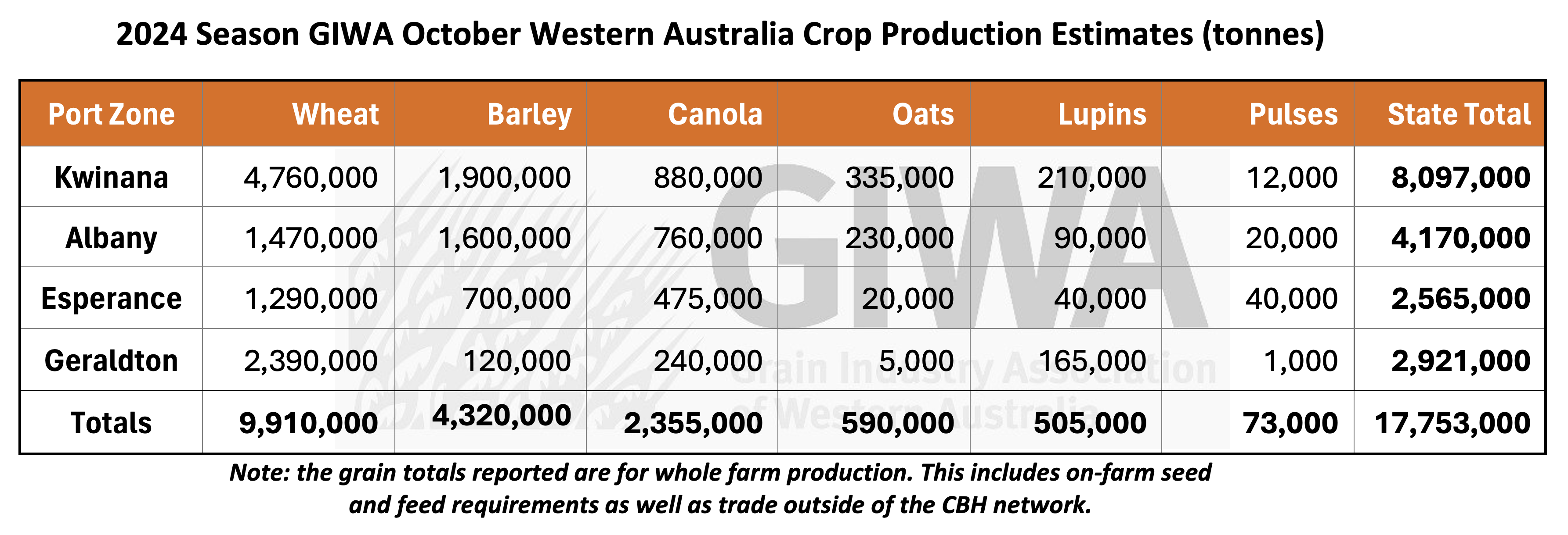
It is now expected that total Western Australian production will be in the range of 17 to 18 million tonnes, a remarkable result given a season characterized by very low rainfall, with the notable exception of the Geraldton region. Grain production out of the Geraldton port zone will become clearer at the start of harvest as the divergence between the excellent crops in the low rainfall east and the poorer crops in the normally higher rainfall west is large and difficult to estimate at the moment.
Water use efficiencies will be in the top few percentiles for many crops in many regions of the state. Due to the wheat crops adjusting to the dry spring by dropping tillers and leaf area, the late rain will have a positive impact on grain size, and we may not see a large kick in screenings as was expected a few weeks ago.
The improvement in wheat crops has and will have the greatest impact on final tonnage for Western Australia. The current estimated tonnage could still climb if the current conditions continue for another week to ten days. Most barley crops were too advanced to benefit from the late rain and despite being less exposed to the dry September, it is expected that a high proportion of the production will struggle to meet the malting standards due to lower retention rates from the very dry grain fill period. It is expected that canola crops will benefit a little from the late rain in the central and southern higher rainfall regions, and this is reflected in an increase in tonnage estimates in this report. Lupin crops that did not get eaten by grubs have hung on and will yield more than estimated a month ago. Oat tonnage for grain in the traditional oat growing regions is driven more by an increase in hectares rather than yield as whilst there are likely to be some very good yielding oat crops, there is a big dry hole from east of Narrogin down to Dumbleyung where a lot of the state’s oats are grown.
Seasonal Outlook
Ian Foster, Department of Primary Industries and Regional Development

Seasonal Climate October 2024
Rainfall
September was dry for most of the agricultural area and continued the rollercoaster pattern of rainfall for the South Coast. Seasonal rainfall (April to September) remains lower than normal for parts of the southern, central and southeast cropping areas (see Figure 1).
The combination of a dry September and well above normal temperatures, has meant soil moisture storage is lower than normal over much of the southern cropping area and South Coast in particular (see Figure 2).
Forecast
Climate conditions in the Indian and Pacific Oceans are neutral. Although some atmospheric indicators in the Pacific have been consistent with La Nina in recent weeks, sea surface temperatures are still within the neutral range.
Half of climate models predict conditions in the tropical Pacific reaching La Nina from October, with the remaining models indicating a near La Nina state. If an event develops in coming months, it is forecast to be relatively weak and short-lived. This has more impact on rainfall for eastern Australia than southern WA.
The Bureau of Meteorology’s seasonal outlook for November to January indicates mostly neutral rainfall chances for much of the cropping area. Many international climate models have a neutral to perhaps wetter outlook for this period.
SAM to remain neutral
The Southern Annular Mode (SAM) has swung between positive values (drier for southern WA) and negative values later in September (return of rainfall). It is predicted to remain neutral for the next few weeks. Short-term forecasts indicate some rain is likely in the coming week, although totals may be modest away from the coast.
Seasonal rainfall patterns show marked contrast between regions
The pattern of seasonal rainfall can be seen in the rain charts in Figures 3 to 6. Cumulative rain is shown against historical percentiles for selected locations. These charts enable comparison between rainfall received and historical records and provide some context to the current season and how it's tracking.
The purple graph line shows current rainfall received. Extending out from the solid purple line are 3 light blue lines which represent a range of historical finishes (dry, average or wet) to the season from the current date onwards.
The contrast in seasonal conditions between north and south is marked, with Binnu tracking very wet, compared with Esperance, which has been following a drier than normal pattern (Figure 6).
The improvement in seasonal conditions over June and July for Kojonup (Figure 5) and Merredin (Figure 4), have flattened from late August. This is consistent with declining soil water storage.
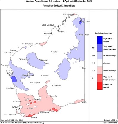
Figure 1: Rainfall deciles for April to September 2024. Source: Bureau of Meteorology (2024)
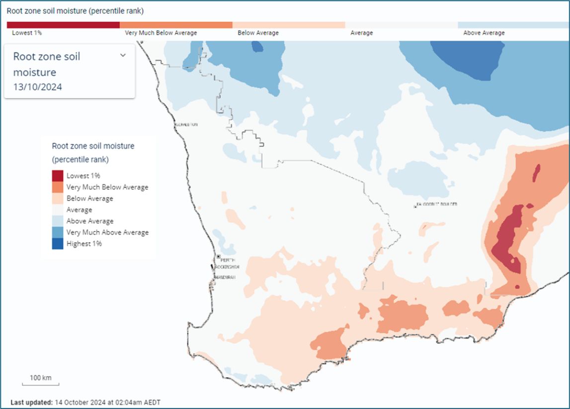
Figure 2: Estimated root-zone soil water percentiles 14 October 2024. Source: Bureau of Meteorology (2024)
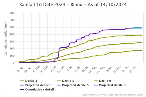
Figure 3: Cumulative rainfall from 1 April to 14 October 2024 at Binnu Source: DPIRD
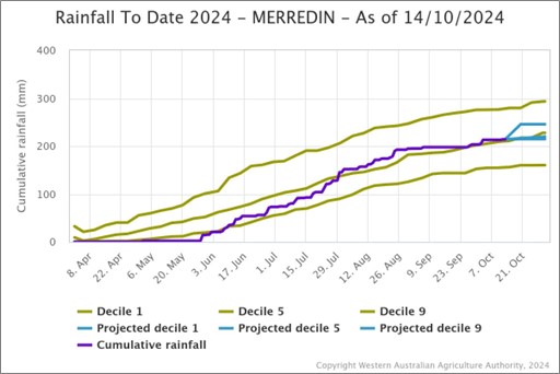
Figure 4: Cumulative rainfall from 1 April to 14 October 2024 at Merredin Source: DPIRD
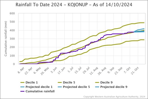
Figure 5: Cumulative rainfall from 1 April to 14 October 2024 at Kojonup Source: DPIRD
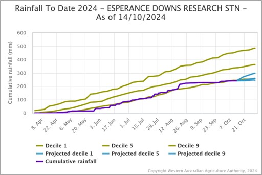
Figure 6: Cumulative rainfall from 1 April to 14 October 2024 at Esperance Downs Research Station. Source: DPIRD
Temperature
Seasonal temperatures throughout winter and spring to date have been very much above normal and are likely to have accelerated crop growth. Daytime temperatures of 30 degrees C or more have been recorded at northern DPIRD weather stations in September and have moved southwards during October (Figure 7). Seasonal forecasts indicate warmer conditions will persist through summer.
The Bureau’s climate model indicates the frost risk during October is near normal, while the risk of unusually high daytime temperatures is above normal from November.
 Figure 7: DPIRD weather stations recording temperatures of at least 30 degrees C during September and October to date. Source: DPIRD
Additional information is available from:
BoM: Decile rainfall for April to September 2024
BoM: Rainfall outlook for the next week
BoM: Seasonal Rainfall Outlook
Geraldton Zone
Snapshot
- Yield expectations: Difficult to judge as historically better areas will be well down while the lower rainfall areas are exceptional, with everything in between.
- Weather impact: Decile 10 rainfall with a late start and now with good rainfall in October. This will benefit crops that are still filling grain. Waterlogging has resulted in problems with weed control and nitrogen top-ups that will mitigate some of the benefit of the rain.
The Geraldton port zone has had an incredible run since the rain started in mid-June. This has continued and the risk of last quarter choke has all most disappeared. The first half of October saw most of the region receiving 20 mm, which combined with above average rainfall in July and August has set the region up for a strong harvest. Total tonnage is going to be limited only by the lateness of the start, problems getting fertiliser on and problems controlling weeds when the ground became untrafficable.
There is just under 1.1 million hectares of wheat in the region which accounts for around three quarters of cropped area, a 30 per cent increase on last year. Much of the increase has been in the low rainfall eastern and northeastern regions that were fallowed during 2023. These areas are having “the best year ever” and grain yields will be well above historical averages. The remainder of the zone is expected to result in average to below average yields, with the exception of some isolated pockets around Mingenew.
Plantings of canola and lupins are lower than usual due to the poor start, with growers substituting these riskier break crops for wheat. Both crops suffered from the late start, and their contribution to the state’s total tonnage for these crops will be minimal. Barley’s contribution will also be minimal.
Rainfall this week has come too late for the earlier finishing crops, although those that are still filling grain will benefit and this could have an impact on increasing the total tonnage out of Geraldton this year. Total grain production for the region could yet exceed 3 million tonnes.
Kwinana Zone
Kwinana North Midlands
Snapshot
- Yield expectations: Very mixed conditions across the whole region. Wheat yields will vary across the region depending on soil type, pre-season rain, fallow in the east and September rainfall. Wheat has benefited the most from final grain fill. Barley on sandplain has struggled, while barley on better soils is expected to be solid. Canola tonnage will be well down on recent years.
- Weather impact: The region received beneficial rain in late September and early October, helping to avoid screenings and improve grain quality.
Crops had canopied up during July and August which was the undoing of them in September. Grain potential faded dramatically during this dry period as they tried to maintain yield levels. As the soil profile dried out, so did the crops and the recent reprieve from light rain this month has arrived too late for the majority of the barley and canola crops. The later canola crops and wheat will benefit, as is the case in other regions of the state, by making up grain yield through grain size. This has been quite noticeable as even though the wheat crops have lost grain fill sites, those that are left are filling well and the heads are surprisingly plump.
The rainfall in late September and early October will help to improve grain quality, particularly in the wheat crops. Barley in the region is mixed with crops on the sandplain struggling through the dry period and are now too advanced to benefit from the mild conditions. Barley on the better soils is solid, and in the western areas, very solid. Cereals are expected to be the winners, with canola yields being variable. The heat during the grain fill period has hurt canola, and there are concerns about how well the crops will ultimately fill.
Budworm has been a significant problem, requiring extensive spraying. There have also been issues with aphids and other pests.
Hay yields have been good, but weather conditions have made baling challenging.
Kwinana South
Snapshot
- Yield expectations: Grain yields will be at the higher end of the scale for many crops and areas of the region.
- Weather impact: The mild conditions and rain have come in time to be of a major benefit to crops.
The higher rainfall regions of the Kwinana zones generally had a later start than other parts of the state and the lateness of crops has been a major concern all year. Although, as conditions continued to improve in July and August, growers reacted by keeping up the inputs to give the crops a chance of hitting maximum yields. The dry September caused a dramatic slide in potential, with the bulked-up barley crops transpiring themselves to death and wheat crops shedding tillers, leaf and grain fill sites. The turnaround in weather conditions in late September and more recently in October has saved many of the barley crops from completely pinching out and has ensured grain size will not blow out retention levels.
The wheat crops have benefited a lot and will now yield in the very top end of recent averages.
Canola was struggling with the late emergence and had a very short flowering period. Most canola crops were still quite green at the end of September and now will fill pods and put on oil to make up a significant improvement in return for growers.
Kwinana North East
Snapshot
- Yield expectations: Very mixed conditions across the whole region. Wheat yields will vary across the region depending on soil type, pre-season rain, fallow and September rainfall. Canola tonnes will be well down on recent years.
- Crop condition: Large areas of wheat sown in 2024 will make up in part for the variable crop growth.
Rainfall has been low all year in the Kwinana North East zone. There are good pockets of country within the zone, notably areas north of Dalwallinu, east to Goodlands around Dowerin, Beacon and the very far east. As you wrap around to the south across the Great Eastern Highway things improve from those areas directly north of here, and most of the south eastern portion of the zone is quite good. Areas north of Merredin and directly east have unfortunately continued to miss out on rain all year and the wheat is now back to breakeven yield levels.
There was a large area sown to fallow and this has helped crops to hang on, although the fallow from 2023 has not had the impact it normally does due to the very low rainfall in 2023. Canola in these dryer areas is pretty dismal, and the high grub pressure in the spring has required expensive sprays for not a lot of income.
Wheat tonnes out of the region will still be at the higher end of the scale, simply due to the very large areas sown rather than high yields.
Albany Zone
Albany West
Snapshot
- Yield expectations: Recovery in grain yield is possible due to recent rain and milder conditions.
- Weather impact: Very soft growing season for crops without waterlogging and frost to contend with.
Crops are a week or two behind those further north and even though the lack of rain in September pulled back potential yields, that has been halted now with a positive change in weather patterns. The improved conditions will see an improvement in the grain yield for wheat and later canola crops. Barley grain size will benefit as well and quite a significant rebound in tonnage is possible, if these mild conditions continue for another week or so.
Tonnage for the zone will be nowhere near what it could have been in late August, although it will be at the higher end of what has been achieved in the past. The lack of waterlogging and frost will see paddock yields more even across the board, without the very high top-end on the ridges and lower yields in the hollows commonly seen in more typical seasons.
Albany South
Snapshot
- Yield expectations: Still time for an increase in grain yield potential for wheat and later canola crops.
- Weather impact: Decile 2 rainfall for much of the region.
- Crop conditions: Soil type differences are showing extremes in crop growth.
The season continues to be a roller coaster ride with rainfall in August picking up the hopes of growers. This was followed by the very poor September rainfall which together with damaging hot winds, reversed the hopes of a decent year. Now with the milder conditions and late rain, the later developing wheat crops and longer season canola crops are getting a kick in yield potential. However, the frost events in the last week may take a bit of the shine off some of these paddocks. The mild conditions have arrived too late for the barley and quicker season canola crops as these are mostly done for the year.
The spring wheat and noodle varieties are filling well with no waterlogging and are benefiting from the improved weather conditions. Pasture growth has been very poor and some of the winter wheat is being considered for hay. Oat hay that has been cut has yielded very well.
The region is having to contend with late grubs in canola, lupins and beans which growers are unaccustomed to, so many have been caught out.
Albany East (Lakes Region)
Snapshot
- Yield expectations: Mostly below average grain yields expected for all crops. Some areas may be better than expected due to very little frost in the region.
- Weather impact: Wheat crops may benefit from recent light rains and mild conditions.
The situation in the region hasn’t changed much from last month with little useful rain until recently and the light rainfall events in the last 10 days have been too little and too late for most crops.
For many growers harvest is just around the corner, with the majority of canola having been swathed or desiccated and barley crops are well into grain fill. Wheat crops may still benefit from the light falls of rain and mild conditions as they are behind the canola and barley in development. Oats for grain are likely to be light weight as many hayed off quickly as the soil profile dried out. On the other hand, the oat hay crops in the more eastern portions of the zone, around Hyden, have been sensational with yields in excess of six to seven tonnes per hectare being common.
This year the region missed out on the frost that can cause havoc, and this will contribute to maintaining grain yield levels.
Esperance Zone
Snapshot
- Yield Expectations: The western side is expected to have average yields, while the eastern side, particularly the Mallee, is very poor. Coastal areas might be above average due to the lack of waterlogging.
- Weather Impact: The region has experienced hot and windy conditions, with disappointing rainfall in September and early October.
The hot winds in September and October with little subsoil moisture under the crops has damaged the potential yields for all grains, and growers are not expecting any nice surprises once the headers roll into paddocks. The Esperance region along with the rest of the south coast received less than 20 mm of rain in several small events during September, and combined with the hot drying winds, this has limited the ability of crops to benefit from the recent rain and milder temperatures. Crops have lost a lot of the potential that was built up in the winter.
Crops went backwards in September and soil type differences were very obvious, with the sandplain, deeper sands and heavy country losing color quickly during this period. The very southern areas near the coast had good potential up until the start of September, although this has evaporated to some extent due to the lack of spring rain. The western mallee areas are good and rain this week will still benefit the later crops.
Barley will be better than wheat unless the region can jag a decent rain in the next week. Canola crops are short and did not bulk up enough to give them a chance of hitting reasonable yield levels.
Grubs have been pretty ferocious this year and most canola and lupin crops have been sprayed at least twice to control the outbreaks.