The 2024 Grain Season - Western Australian grain production estimates continue to climb
The continuing rainfall across the Western Australian grain growing regions, combined with warm weather during the last few weeks, has pushed crops ahead of where they were a month ago. Soil moisture reserves are gradually improving, and the crops have accelerated their development to be close to normal, rather than behind in growth stages as they were in July before the rain started to fall.
Growers have reacted to the season and have increased fertiliser applications. Crops have responded by bulking up to be in a position of high-top end potential if the rain continues into the spring. The outlook for this occurring is positive based on current climate model outlooks.
For most regions, the crop yield potential is currently sitting around recent high averages, rather than longer term averages as it was a month ago. There is now the potential for total tonnage from all crops across the WA grain belt to be in the high teens. At the moment, total tonnage is likely between 17 and 18 million tonnes for all grains. To achieve this, the rainfall is going to need to be at least in the decile 5 range for the remainder of August and September, as well as the heat holding off during critical grain fill periods.
Not all regions have continued to improve and there are still areas of the Great Southern and Esperance that are well down on average annual rainfall.
Cereals have benefited the most from the step up in rainfall, particularly where conditions at establishment were favourable and crops established evenly. Canola is going to be down on yield in all areas other than the south coast, the western part of the Albany port zone and the west coastal regions where the lack of waterlogging is going to result in high whole paddock grain yield averages. In all other regions, canola crops are either too late, too patchy, or both to achieve anything other than average or below average grain yields. Lupins are late but good in the southern regions, and OK-to-poor in the northern regions. Oats have cracked along, relishing the wet, warm growing conditions and have improved dramatically over the last month to be currently in the higher end of potential grain and hay yields.
There is a relatively large area of crop in the ground of around 9 million hectares, which will buffer the downside of production estimates to some extent if spring growing conditions prove unfavourable.

Seasonal Outlook
Ian Foster, Department of Primary Industries and Regional Development

Rainfall
July rainfall was near normal for much of Western Australia’s cropping region, and wetter in the north.
However, seasonal rainfall (April to July) remains much lower than normal for much of the cropping region, apart from the north (see Figure 1).
Soil moisture storage is lower than normal for the south coast (see Figure 2).
Forecast
Climate conditions in the Indian and Pacific Oceans are neutral, and while chances are rising for a La Nina event, climate models are not all in agreement. Climate conditions in the Pacific and Indian Ocean are likely to remain neutral for the rest of the growing season.
Weather forecasts for August indicate rain is likely to continue throughout the month, consistent with a negative Southern Annular Mode pattern.
The Bureau of Meteorology’s seasonal outlook for September to November has neutral chances of rainfall for much of the cropping area. Many of the international climate models also have a neutral outlook for this period. Most models had a below-normal rainfall outlook at the same time in 2023.
Good rain in July and early August has improved seasonal rain accumulation for many locations away from the south coast. In Figures 3 to 6, cumulative rain is shown against historical percentiles for selected locations. They enable comparison between rainfall received and historical records and provide some context to the current season and how it's tracking.
The purple graph line (in Figures 3 to 6) shows current rainfall received. Extending out from the solid purple line are 3 light blue lines which represent a range of historical finishes (dry, average or wet) to the season from the current date onwards.
The contrast in seasonal conditions between north and south is marked, with Binnu tracking very wet, compared with Esperance.
Esperance requires well above average rain for the rest of the season to make average (Figure 6).
Good rain in June has brought Kojonup up to near normal for the season to date (Figure 5), and July rain has improved conditions for Merredin (Figure 4).
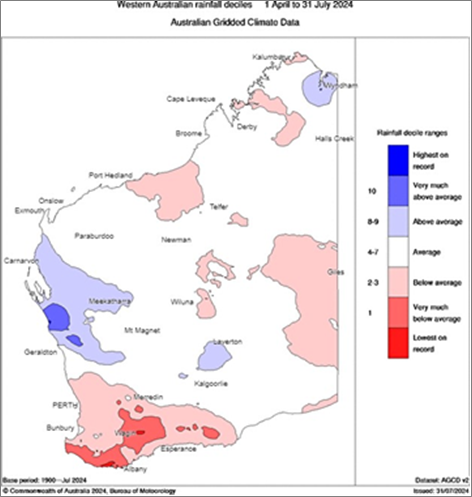
Figure 1: Rainfall deciles for April to July 2024. Source: Bureau of Meteorology (2024)
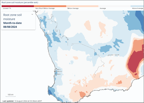
Figure 2: Estimated root-zone soil water percentiles at 8 August 2024. Source: Bureau of Meteorology (2024)
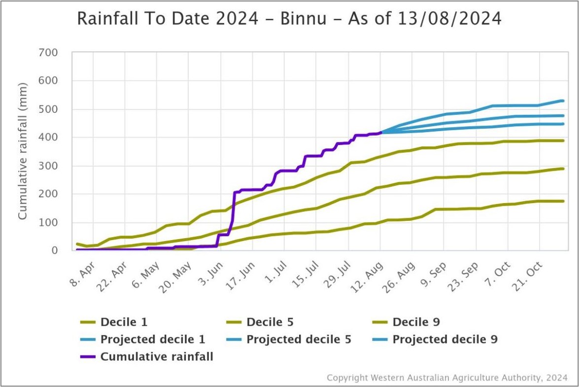
Figure 3: Cumulative rainfall from 1 April to 13 August 2024 at Binnu. Source: DPIRD
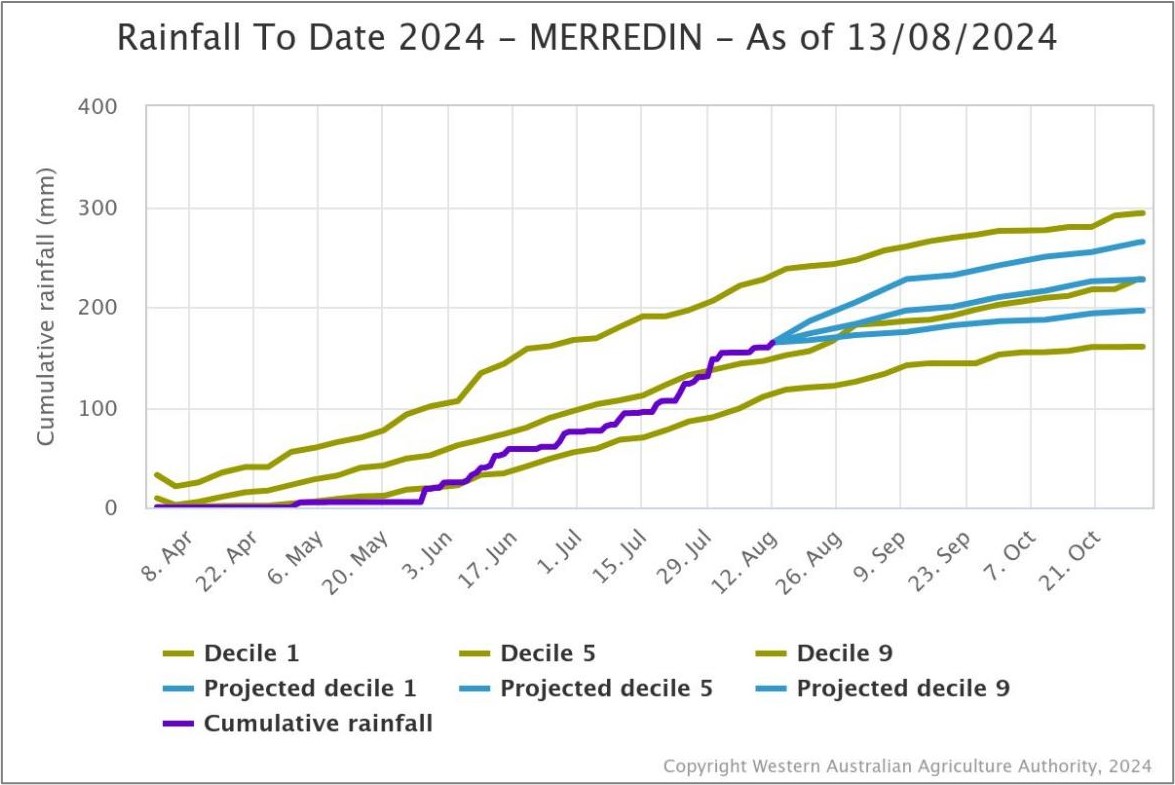
Figure 4: Cumulative rainfall from 1 April to 13 August 2024 at Merredin. Source: DPIRD
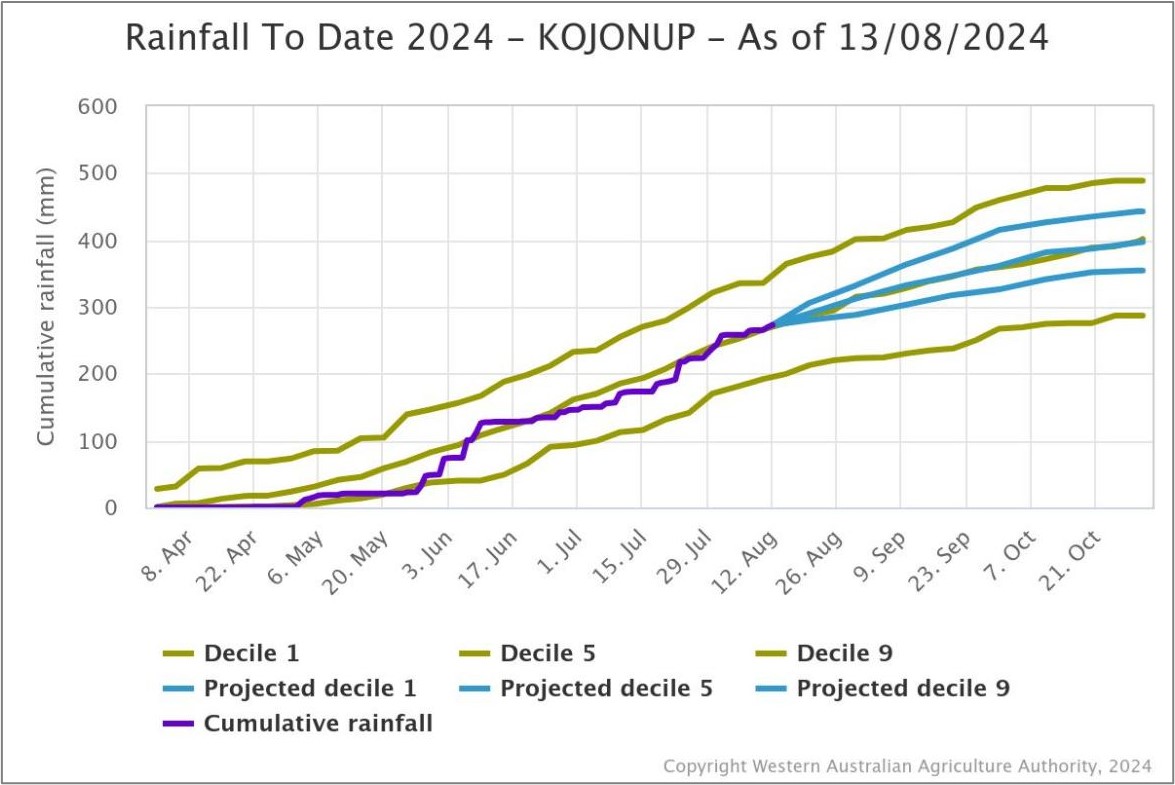
Figure 5: Cumulative rainfall from 1 April to 13 August 2024 at Kojonup. Source: DPIRD
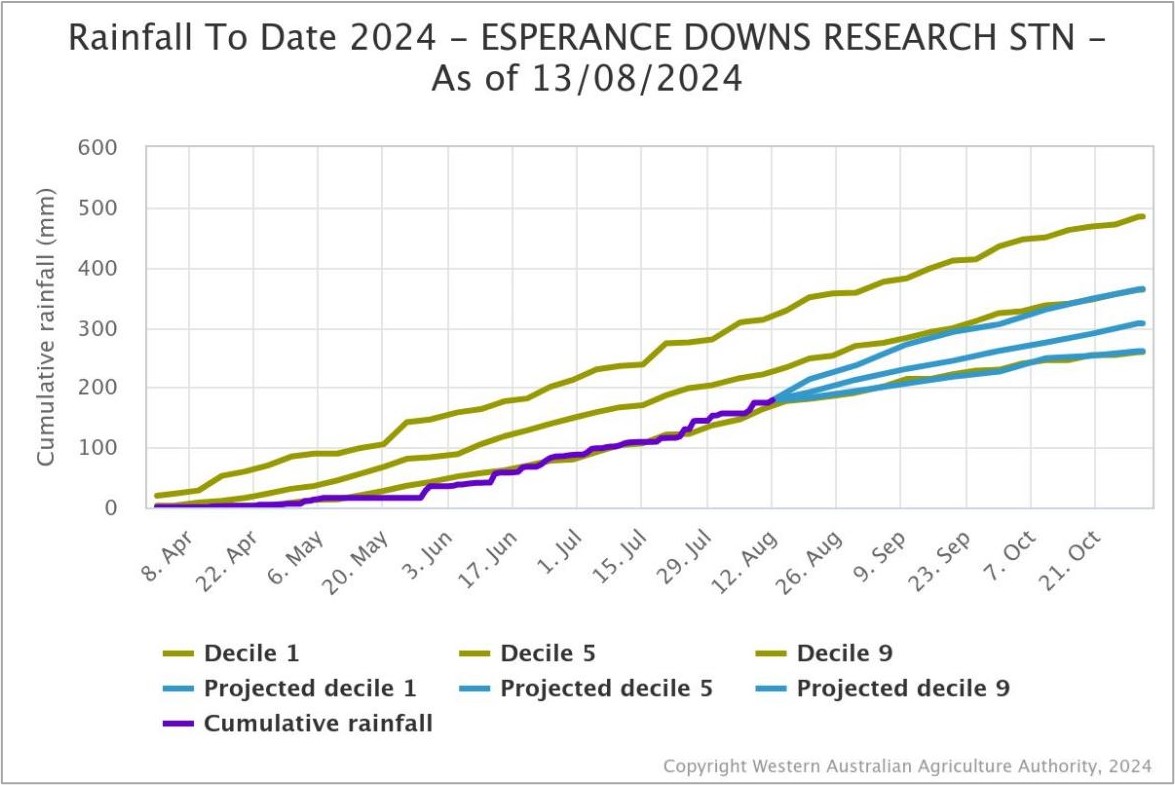
Figure 6: Cumulative rainfall from 1 April to 13 August 2024 at Esperance Downs Research Station. Source: DPIRD
Temperature
Seasonal temperatures throughout winter have been very much above normal and are likely to have promoted crop growth. Seasonal forecasts indicate warmer conditions will persist into spring.
BoM’s climate model indicates the frost risk over September and October is lower than normal, while the risk of unusually high daytime temperatures is normal for the northern cropping area.
Additional information is available from:
BoM: Decile rainfall for April to July 2024
BoM: Rainfall outlook for the next week
BoM: Seasonal Rainfall Outlook
Geraldton Zone
The turnaround in conditions in the Geraldton Port Zone continues to be amazing, with soil moisture profiles full or over full now, from being completely dry in mid-June. This has staved off a potential disaster for growers, who were facing two poor years in a row, but has brought some challenges to now get crops up to potential yields to match the rainfall.
Saturated profiles have been a challenge for weed control and fertilising crops and many crops will now be limited by being underdone for nutrition, weeds and the impact of less than perfect establishment earlier in the season. The crops that emerged later are generally in better shape than those that came up early but patchy, and this is particularly the case with canola.
The lower rainfall eastern and northern regions of the zone are having an absolute cracker of a year with cereals potentially going to yield more than double their long-term averages in some cases. The normally more reliable medium rainfall regions are not likely to hit those levels. Even so, the potential for the region to hit 3 million tonnes of total grain production is on the cards if the heat does not come on too early. The heat from now on will determine the outcome and this could swing tonnages a lot either way, as even though there is adequate moisture to finish crops, they are later than normal and if exposed to excessive heat during grain fill, their top end will be limited.
Kwinana Zone
Kwinana North Midlands
Overall, crops in the region are very good with the combination of adequate rain and warm growing conditions allowing crops to hit high nitrogen use efficiencies from west to east in the zone. However, crops are a bit behind where growers would like them to be, and this will limit the top end grain yield potential for wheat and canola. Barley crops will be less affected, and many, even those in the eastern areas, currently have 3t/ha grain yield potential and in the west, yield potential is well above this. Barley was substituted for some canola paddocks by many growers as the start to the season pushed out to being later, and this extra area and the good condition of most barley crops will result in a lot of tonnes coming out of the region if the finish to the season is as forecast.
The dry start has resulted in the earlier sown crops being patchier than the later emerging crops and this has carried right through to present. This is more pronounced in the canola and wheat crops.
Disease and insects have started to get a move on following the warm wet conditions over the last few weeks and growers need to get these under control. Green peach aphids have caused havoc in some canola crops in the west and it’s shaping up to be a big diamond back moth year for canola. Sclerotinia is present in canola, as is spot type net blotch in barley and septoria in cereals.
The regular oat hay growers increased their planting by a paddock or two in response to the run down in stocks from the dry 2023 growing season and late break to the season in 2024. These crops have really kicked in the last few weeks and are relishing the growing conditions.
Kwinana South
Regular rainfall in the back end of July and start of August has had growers re-loading with nitrogen as the grain yield potential kept increasing. The warm conditions have allowed crops to make up time in growth stages to be back to ’normal‘ for this time of the year.
Soil moisture profiles have improved over the last month as has the crop biomass, and this will need to be supported by more rainfall during spring for crops to hit their current potential. There are still a few gaps in the region where rainfall totals have been a bit light on, although as a whole the region is in pretty good shape heading into spring, with crop grain yield potential sitting at recent averages.
The later emerging crops in the western regions that were behind are still a little behind where you would like them, although they have come a long way in the last three weeks and now mostly look sensational. The lack of waterlogging means they are very even across whole paddocks, which will contribute to high paddock grain yield averages.
Intended canola area and some pasture was substituted for oats and whilst the split with grain and hay can of course vary depending on price and climatic conditions in the spring, there is certain to be more oats for grain than estimated a month ago.
There was a slight increase on oat area planted in the traditional oat growing regions for both grain and hay. Some growers in the western areas, where there was more rain earlier in the season, increased plantings quite a bit. This has resulted in total oat plantings in the zone being up by 15-20% from 2023. Oats in all regions have picked up in the last five weeks since the July Crop Report and grain and hay yields are now on track to be in the upper end of historical yields. The increase in area planted was limited to dedicated oat growers rather than ’new‘ growers and there was little if any increase in area in the lower rainfall areas away from Hyden/Newdegate, where they experienced very good autumn rains.
The later start has resulted in low levels of leaf diseases in cereals and canola to date.
Canola crops look like they are going to need some close management as insects that have been conspicuously absent till now have suddenly turned up.
Kwinana North East
Crops in the low rainfall zones of the central grain belt look excellent considering the rainfall to date. In particular, wheat is well grown, well tillered and many crops look to have 3t/ha grain yield potential. Although to reach this, there is going to need to be at least another 40-50mm of rainfall between now and the end of September, otherwise the yields will slip back to the 2t/ha range.
Crops on the well managed fallow from 2023 look particularly good and should hold their potential even if rainfall is light over the next few weeks. The area of crop on fallow is relatively high due to the poor season in 2023 and the area of fallow in 2024 is low, even though it was a late start for many growers. Growers responded to the season once it started to rain and ended up planting an extra paddock or two which has resulted in an historically high area of crop planted in the region.
Canola area in the region has come back from previous years due to the dry autumn and late break to the season, with most growers reverting to a wheat-dominant program. These large areas of wheat will contribute a lot of grain to the state if the rain keeps coming and the heat holds off, and could result in large swings up or down depending on what happens over the next six weeks.
Growers in these lower rainfall regions are becoming more responsive to the season and now regularly fertilise for higher grain yield potential compared to five years ago. This practise change has been facilitated by more soil amelioration, cleaner weed-free crops and precise timing of general crop agronomy. The result is that when a good year comes along, the gains are amplified.
Albany Zone
Albany West
Crops are in very good shape west of Albany Highway. These areas had an earlier start than many regions of the state and the lower-than-average rainfall has meant there is less waterlogging than normal. There has been enough rain to keep crops growing and because they went in quite early, they will be buffered from falling away in grain yield potential to some extent if the season cuts out.
Barley is the standout this year and most crops are in line for some very good yields. Canola is not far behind with most well bulked up and in the early stages of flowering, which is perfect for the region. Leaf diseases in both are starting to emerge now from the moist warm conditions, although growers are aware of this and this should limit the impact of net blotch in barley and sclerotinia in canola from having any impact on final grain yields.
Crop potential falls away dramatically east of Albany Highway where rainfall has been less, and crops came up later and patchy in many cases. This area of lower potential stretches east right across to Jerramungup, with few growers hitting 200mm of rain for the year to date. Crops through here will need a very good spring to hit anywhere near average grain yields.
Albany South
Crops in the southwest regions look remarkably good for the rain they have had. Overall crops went in early and are well advanced, with many barley crops now with their flag leaf out. The warm temperatures have pushed crops along, accelerating through their growth stages whilst still maintaining biomass. Soil moisture profiles are low, and the rain is going to need to keep falling if crops are going to yield as good as they look now.
Away from the coast and east of the Stirling ranges, crops are nowhere near as good, and they will struggle to hit average grain yields. This poorer area is quite large and could extend north to the southern Lakes District if the season has a quick cut out.
Albany East (Lakes Region)
Conditions have improved in the last month from ’shut the gate‘ for some growers to the majority of growers needing to top up with nitrogen as rain in the district picked up during late July and early August.
Cereals have caught up in growth from being behind where they would normally be last month, to many now having at least average grain yield potential. Rainfall has been a bit hit and miss for growers and there are some areas that have continually missed out. Most growers will need a couple of rainfall events of 20-30mm to hit average grain yields.
The cereals are in better shape than canola, which suffered more from patchy emergence, and whilst crops have filled in over the last month, biomass is down on where growers would like it to be.
Barley crops have improved considerably from where they were a month ago. Disease levels are low and they and responding to nitrogen top-ups and have pushed out reasonable tiller numbers. This will give them a chance to hit close to average grain yields if the rain keeps coming.
There were a few frosts in the region two weeks ago, although no crops were at vulnerable stages when these occurred. Frost can still cause trouble in the region and the intensity and timing of frost events in the spring, together with rainfall, will determine the final outcome.
Esperance Zone
Conditions in the region improved during July with just enough rain to keep crops ticking along rather than picking up to the extent that they have in most of the grain growing regions to the west and north. Very few growers other than those right on the coast have received more than 200mm for the year so far and unless there is a couple of decent rains in the next month, crops will simply not have enough soil moisture reserves to handle the inevitable heat that will come during spring.
The thin coastal strip has benefited from the lower-than-average rainfall this year, resulting in less waterlogging than is normally the case. All crops on the coast are in very good shape with noticeably more density and bulk than further north. Whilst these crops are in line for some very good grain yields and the contribution in total tonnes in the region will be significant, the area itself is small.
There are some good areas of crop in the western portions of the zone and, with a good spring, these have the potential to yield close to average. The eastern portions have been drier all year and this is still the case.
Many crops suffered from staggered and patchy emergence, and this is particularly the case with canola away from the coast. Irrespective of what happens from now on, average canola grain yields will be capped away from the coast to no more than average yields at best. Cereals have more of a chance to creep up in potential yield from where they are now, although with the very low decile rainfall year up to now, more rain will be needed for the region to reach the current total tonnage estimates.