The 2021 Season – Majority of huge value of grain still in the paddock

Harvest in the Western Australian grainbelt has been a stop-start affair due to continued rainfall events and the unseasonal cool conditions slowing down the “finish” of crops. Growers are finding all crops are yielding better than expected except for the badly frosted areas in the north-eastern and far eastern regions of the state. The cool conditions in spring have had a major impact on allowing crops to fill heads and add weight in all regions.
Heat shock in the spring is usually the limiting factor with grain yield and the lack of it this year has had a staggering effect on the ability of crops to finish, even where there was very little finishing rainfall.
The full impact of the frosts across large areas of the central grain growing regions and more recently in the southern regions is still unknown, although it is now clear there will be more grain around than estimated a month ago.
In all regions where harvesting has been underway for a few weeks, canola crops are yielding higher than expected even where there were losses from the repeated wind events over the last few weeks. Canola crops in the southern regions have benefited from the soft finish as well and total production could end up just short of 3 million tonnes.
Cereal crops are yielding better than expected although results so far are mainly from the better paddocks. Lupin, pulse and oat grain yields will all be above average.
There have been a series of storm events that have caused significant loss from hail in strips, although the overall impact on total grain production for the state will be minimal.
Grain quality is starting to be impacted by the wet conditions and will start to slide if wet weather continues. Harvest is behind schedule for most growers and the large crop with good prices has growers nervous because “you can’t count it until it’s in the bin”.
Seasonal Outlook
Ian Foster, Department of Primary Industries and Regional Development

DPIRD Climate Summary
Rain so far
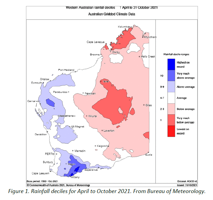
- Below average rainfall in September continued the late-season pattern of drier and warmer conditions for northern and eastern agricultural areas. Root-zone soil water storage was well below average in these regions but remained above average for the Great Southern and western South Coast, which had near-normal rainfall. Growing season rain to date (April to October) is now near-average or wetter for most of the agricultural area, with parts of the western South Coast and Great Southern being much wetter than normal (Figure 1).
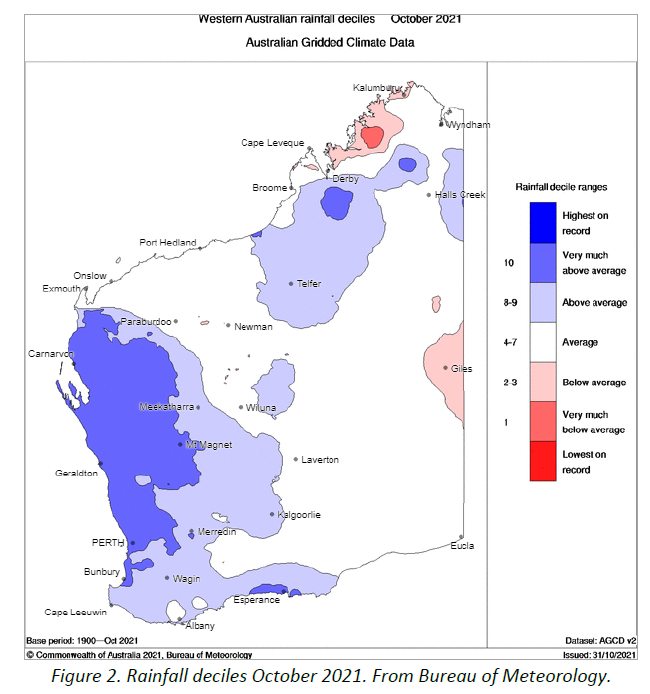
- October rain has been well above average for most agricultural areas (Figure 2). Soil water storage has increased in the wetter areas but may be too late for crops and pastures.
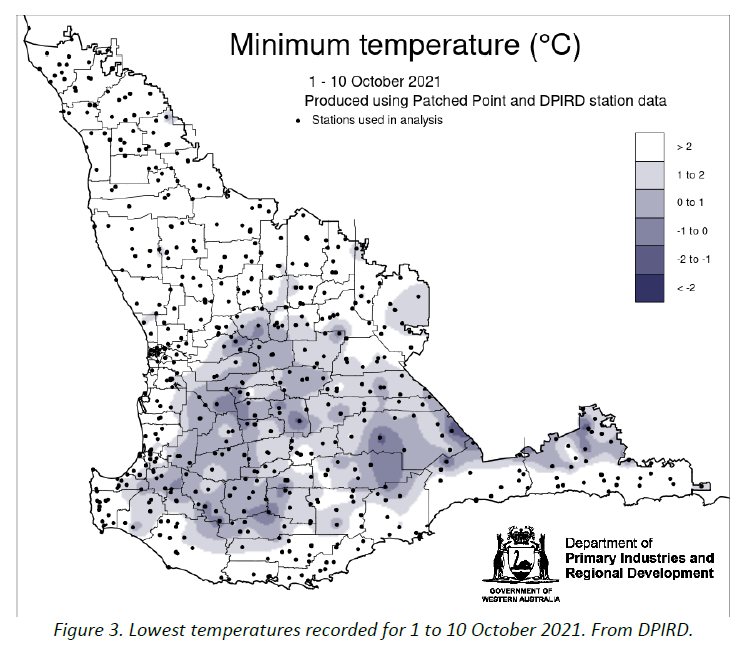
- Some frost events have occurred over central and southern cropping areas in the first part of October (Figure 3), although these seem less severe than in September.
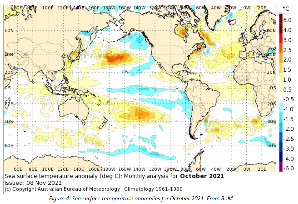
- Climate conditions in the Pacific Ocean are indicating continuing cooling, with increasing likelihood of La Nina event developing from November 2021. The negative Indian Ocean Dipole (IOD) event in the tropical Indian Ocean still lingers and leaves warmer oceans to the northwest of WA (Figure 4).
Rainfall outlooks
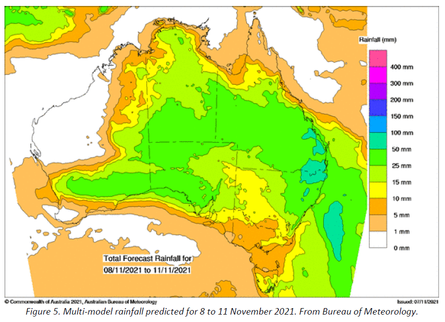
An upper-level trough was forecast to bring significant light rain over northern, central and eastern agricultural areas on Tuesday 9 November. See Figure 5 for a multi-model forecast of rain, issued 8 November. Latest forecast is available on the BoM’s WATL pages.
The rainfall outlook for November from BoM, updated 4 November, indicates a spread of rainfall probabilities from below normal rain for the southwest, to wetter conditions for the far southeast. This is supported by ECMWF multi-week outlooks, which indicate above-normal rainfall for central and eastern agricultural areas.
The Southern Annular Mode (SAM) index has mostly been positive for the past five weeks. It is forecast to remain positive for October to December. This forecast is supported by a combination of a strengthened polar vortex over Antarctica, as well as the likelihood of La Niña development. Positive values are associated with weaker westerly winds and wetter conditions for the South Coast.
Outlook for November 2021 to January 2022
- The negative Indian Ocean Dipole is waning, though eastern Indian Ocean temperatures reman slightly above normal (Figure 4). The El Niño–Southern Oscillation is neutral. All seven surveyed models anticipate La Niña thresholds will be met or surpassed from November. La Niña increases the chances of above average spring rainfall for much of eastern and northern Australia. See BoM’s Climate Drivers summary.
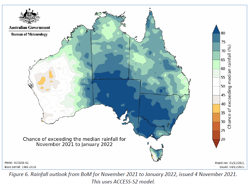
- BoM seasonal rainfall outlook for November 2021 to January 2022 has a neutral outlook for most of the agricultural area of WA (Figure 6). See the BoM’s seasonal outlook video for more details. The wetter outlook for much of central and eastern Australia is likely related to warmer than normal sea temperatures to the north of Australia, as well as the expected La Nina event.
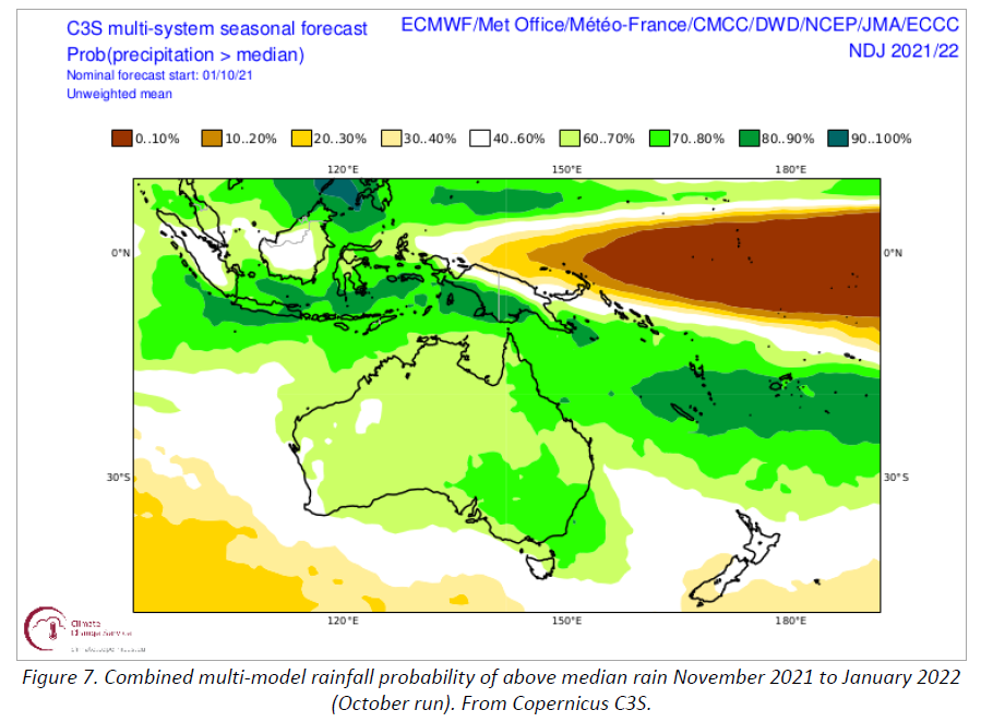
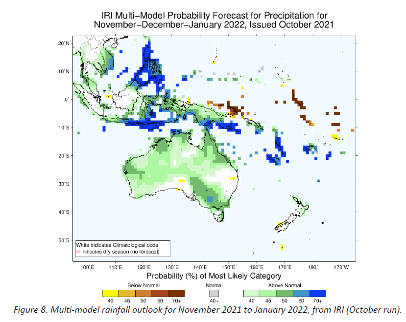
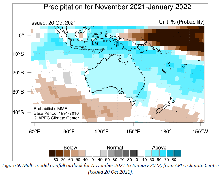
- International climate models are showing neutral to above normal rainfall outlooks for much of WA for November to January 2022. The spatial distribution of rainfall probabilities is similar to the BoM outlook Australia (Figures 7, 8, 9).
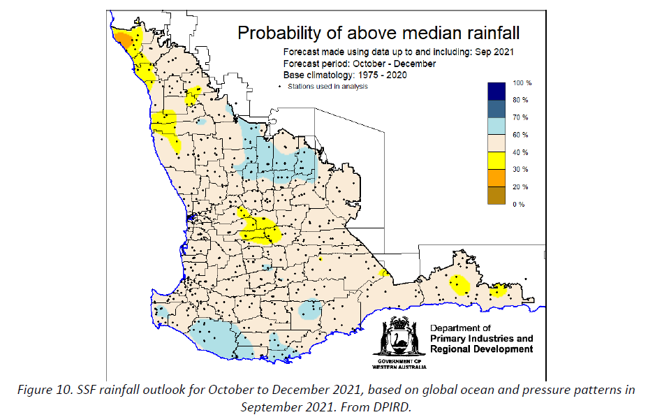
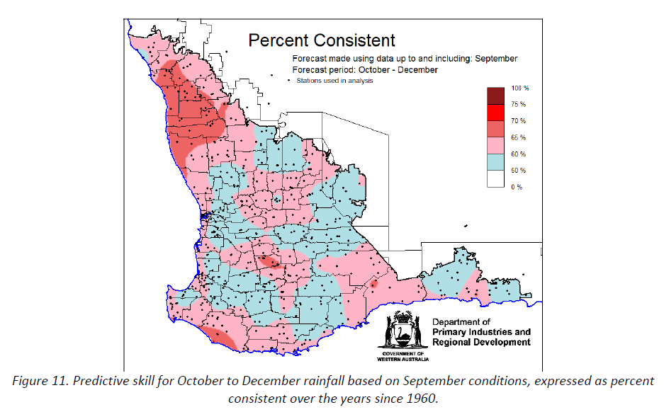
- DPIRD’s Statistical Seasonal Forecast (SSF) for October to December 2021, based on September global conditions, has a largely neutral rainfall outlook the agricultural area and southwest (Figure 10). The SSF’s historical predictive skill for that season and lead-time is poor to medium for most parts of the region (Figure 11).
Additional information is available from:
DPIRD: Seasonal Climate Information
BoM: Seasonal Rainfall Outlook – weeks, months and seasons
BoM: Decile rainfall for April to June 2021
BoM: Landscape soil water balance
Geraldton Zone
Harvesting has been underway for several weeks, although growers have been held up with repeated rainfall events and are behind where they would like to be at this time of the year. Many areas have now had up to three separate rainfall events since harvest commenced and due to the stormy nature of these events, some have received up to 100mm in total.
The repeated rain, hail in strips and wind has had an impact on reducing canola grain yields from all paddocks. This is particularly evident in the early sown paddocks due to pod loss, hence the really top end results were not achieved. The later sown paddocks however have generally yielded more than expected. The overall net result is still a very good outcome considering the lack of finishing rain and unfavourable weather during harvest.
The wheat that has been harvested is going well over what was estimated prior to harvest. The relatively cool finish to the season for the region has had a major impact on the ability of cereal crops to fill heads.
With multiple rainfall events already, if there is more rain over harvest, it is likely that downgrades in wheat quality will start to occur.
Kwinana Zone
Kwinana North Midlands
Canola grain yields so far have been very good with the better areas going 1.8 to 2.6T/ha with oil content in the mid 40’s and up to 48 per cent. The wind and isolated hail events have knocked the top off canola grain yields, and some areas also got very wet in winter in the higher rainfall regions, but taking all this into account, growers are pretty happy with the end result.
The reduced barley area in the zone has been averaging around 3T/ha with frost taking the top off yield in many paddocks. There has been very little wheat harvested to date and estimates are that areas not affected by frost will mostly exceed 3T/ha.
Lupin crops have finished well, and most are expected to yield between 2 to 3T/ha.
Overall, it is going to be a good result for the region even though harvesting has been slow going and growers are nervous that harvest will be further disrupted. These thoughts are shared in other areas of the state too.
Kwinana South
In the region, it has mostly been canola and some barley harvested to date. The recent rain has been frustrating here because, like other areas further north, crops were too advanced to benefit and the loss in canola crops from pod shatter continues to mount. Even so, the better crops in the higher rainfall regions are going 3T/ha over large areas. Barley has been yielding in the 5T/ha range even with the wet areas included. Grain yields may fall away in the very wet areas of the western regions once more crop is taken off. The eastern portions of the zone are also very good even where there were several frost events in September.
The wheat crops overall were less affected by the frosts and benefited more from the cool finish. Barley grain yields in the eastern areas of the region will mostly exceed expectations. Lupin crops will yield very well from the extended pod fill, as will the small areas of milling oats.
Kwinana North East
Canola crops are yielding above expectations for most growers. There are plenty of 2T/ha whole paddock averages coming in, even where there was substantial pod loss from wind events.
Barley has been good where not frosted. The wheat and barley in the frosted areas have recovered to some extent where there were reserves of sub-soil moisture and grain yields are a little more than expected. The very bad areas, particularly in the far northern and eastern areas where it was also dry, are still poor to very poor. The good areas of the region are going to be above average and even though the frosts have taken off several million tonnes of potential grain yield across the region, due to the large area planted, total grain production will be close to average or above average.
Albany Zone
Albany West
Small areas of barley have been harvested to date with barley that looks like 3T/ha going 4.5T/ha and canola 2.5T/ha to 3T/ha. These are the best paddocks and average paddock yields will come off a bit as more area gets harvested. Even so, the general comment is that whilst the wet areas are substantial, the good areas are very good and will help to keep paddock averages up.
Wheat not impacted by frost is expected to go 5T/ha plus as it has benefited more than the barley and canola from the cool finish. The late October frost has taken out wheat at vulnerable growth stages in areas to the west, and for some paddocks the loss is going to be greater than 50 per cent. There has also been frost damage to cereals in the north-eastern regions during September and early October which will take the top off grain yields.
Albany South
Harvesting is just getting going in the region and early indications are that grain yields are going to be above average for all areas away from the coast. Recovery from the waterlogging has been substantial although whole paddock averages are going to be impacted by the poor spots. The re-sown areas could end up with barley grain yields of greater than 3T/ha.
Away from the coast and waterlogged areas to the west, barley and canola yields have so far come in well above expectations. Wheat crops are still filling heads and are benefiting from the sub-soil moisture reserves and cool conditions, with many now filling 5 grains wide. The wheat crops that escaped the frost are going to be very good.
There are areas of frost in the northwestern areas of the region that will pull cereal yields back, whilst the western areas where less frost and waterlogging occurred, will have well above average grain yields.
Albany East (Lakes Region)
The Lakes region is still set for one of the best results for a long time. The early start, good rainfall, lack of frost and now cool finish have all contributed to the region expecting up to 50 per cent higher grain yields than average for all crops.
Only small areas of crop have been harvested so far, although crop estimates for barley, wheat and milling oats look to be 3T/ha plus, canola 2T/ha plus in the better spots and overall at least 1.5T/ha. Oat hay yields were spectacular with the best paddocks going 8 to 9T/ha. Wheat grain yields look like they will be close to barley for a change and if that ends up being the case, the region will produce a lot more wheat than it has for a long while.
Esperance Zone
Harvesting is still in its early days in the Esperance port zone, although it is already looking like the region is on target for a record or close to record tonnage. Wheat and barely grain yields have been very good in the drier areas of the zone and canola is excellent as well. There are areas of frost and more recently hail that has significantly impacted crops in isolated spots. Some canola crops have lost up to 500kg/ha from repeated wind events although in the drier areas they are still going 1.2 to 1.3T/ha and the wetter areas are going a solid 3T/ha for the better crops. In the drier areas to the west of the zone around Mount Madden where they have had a poor run for a few years, the canola has been going around 1.5T/ha and cereals 3 to 4T/ha.
Wheat has benefited the most from the cool finish and pre-harvest estimates are all above average for the different regions in the zone. For some crops, based on head size and slow grain fill, grain yields could be well above average.
All lupin and pulse crops look very good, and growers are expecting top end yields.
In the zone, there has been a lot of crop-topping of crops to control ryegrass and ryegrass ergot and to finish off canola and barley.