The 2023 Grain Season - Recent rain has arrested the slide in grain yield potential for Western Australia
Rain across large areas of the Western Australian grain belt a week ago, has halted the dramatic slide in grain yield potential that was occurring in the northern regions and improved the prospects for growers in the southern regions.
Total estimated grain production for the upcoming harvest in Western Australia has dropped by nearly 1.5 million tonnes since the last Crop report a month ago. This decrease in potential would have continued without the one-off recent rainfall event last week. Rainfall in the dry areas of the state continued with the trend all year of light falls and whilst too late for many crops in the low rainfall regions of the Geraldton and Kwinana Northeast port zones, crops that were hanging on will benefit with a slight lift in potential and a significant lift in grain quality potential. For many growers, the rain has changed their prospects from a negative profit year to breakeven or slight profit.
Crops in the low to medium rainfall zones in the central and southern grain growing regions will now hold potential grain yield to be close to ten-year averages rather than recent averages. Crops in the state’s higher rainfall zones along the west coast in the Kwinana zones and Albany port zone, and including the south coastal Albany and Esperance port zones, are now back on track for grain production close to recent averages.
High screenings in cereals in the drier areas of the state were shaping up as being a major issue prior to the rain. In response to lack of spring rain and low sub-soil moisture reserves, crops were dropping tillers and reducing the available grain production sites in the heads. With the recent rain, having fewer grains to fill will result in an increase in grain size across several million hectares of the grain growing regions. This single rainfall event will increase yields slightly, as well as push many crops into the higher priced grain brackets.
The majority of the state’s grain crops have escaped significant frost damage. There are pockets of both stem frost and flower frost, although the impact on total grain production is expected to be minimal. Crops in the southern areas of the state will still be vulnerable over the next few weeks which could push production estimates lower. Other than that, even without further significant rainfall, current production estimates should hold.

Seasonal Outlook
Ian Foster, Department of Primary Industries and Regional Development

Rainfall
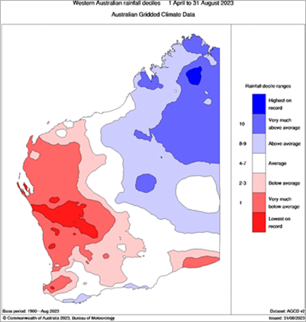
Seasonal rain April to August was very much drier than normal for northern and eastern agricultural areas and parts of the south-west. Coastal parts of the south coast were wetter than normal (Figure 1).
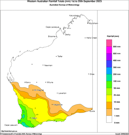
Rain to date this month has mostly come from one event on 14 September and has helped to maintain potential yields in the south. Northern agricultural areas away from the coast have received less than 10 mm (Figure 2).
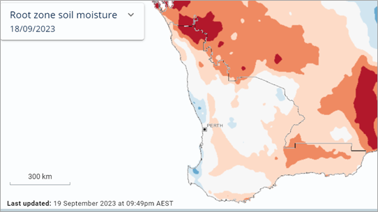
This is reflected in estimated root zone soil water storage (Figure 3). Although storage has improved, crop water usage and evaporation are also higher.

Figure 1: Rainfall deciles April to August 2023. Source: Bureau of Meteorology (2023)

Figure 2: Rainfall for 1 to 20 September 2023. Source: Bureau of Meteorology (2023)

Figure 3: Estimated relative root zone soil water to 19 September 2023. Source: Bureau of Meteorology (2023)
Forecast
An El Nino event has been announced by the Bureau of Meteorology, along with a positive Indian Ocean Dipole. Their combined impact historically suppresses rainfall over much of Australia in winter and spring. The El Nino will likely continue into early 2024, also influencing a later onset of the Australian monsoon.
Climate models continue to indicate that below normal rain is more likely over the coming months for most of Australia. Atmospheric pressure is likely to remain above normal south of Australia, which is associated with lower rainfall over southern WA.
Temperature
August was much warmer than normal, as predicted. In contrast, frosts occurred in early September over central and southern agricultural areas.
For October to December, above median maximum temperatures are very likely for almost all of Australia. Chances of unusually high maximum temperatures are more than 4 times likely than normal for most of western and central WA.
Additional information is available from:
BoM: Decile rainfall for April to August 2023
BoM: Rainfall outlook for the next week
BoM: Seasonal Rainfall Outlook
Geraldton Zone
The recent rainfall arrived too late for the northern parts of the region. For some paddocks in the very dry areas that had a bit of green left, it may help with screenings and a possible improvement of 100-200kg per hectare. In the western regions where grain yield potential is higher, it will hold the grain yield potential that was there. There was a huge amount of damage from the wind that arrived with the rains. Some paddocks with very droughted crops and weak stems lost up to 50% of the heads; a nail in the coffin for a few people. The heavier clay and clay loam soils will not contribute much grain to the zone this year.
Whilst the wind with the rain was unpleasant, the net result of the rain will be positive for the region and on a more positive note, the well managed ameliorated soils have again performed exceptionally well, with some paddocks looking like they may yield close to 1 tonne per hectare on around 100mm of growing season rainfall. There has been less rain in the region than the very dry 2007 year where the zone produced 1.5 million tonnes of total grain. This year, with less rain than 2007, the crops on the lighter soils will produce double 2007’s grain yields.
The canola from Morowa to Dalwallinu has mostly failed and those paddocks that were not sprayed out will yield less than 0.5 tonne per hectare due to low rainfall and, prior to the rain last week, the wind snapping the stems of the lighter crops. The canola is doing well in the western areas, even with minimal rainfall.
The coastal strip will produce the bulk of the grain in the Geraldton port zone, together with the low rainfall regions along the strip through Mullewa that received 90 -100mm rainfall back in March.
Kwinana Zone
Kwinana North Midlands
Rainfall totals from last week’s falls were around the 20mm mark in western areas, but quickly fell off to below double digits in the eastern areas. Rain in the western zone has made a massive difference and will add tonnes and quality. Whilst in the eastern areas, the rain will add more to quality than tonnes. The strong winds prior to the rain caused damage to many crops from either lodging or head loss.
The historically ameliorated soils from 2008, 2009 and 2010, which have been ameliorated again with different machinery, are producing remarkable results on minimal rainfall and are likely to see average yields achieved, with some paddocks performing above average.
There simply has not been enough rain for the heavier clay soils this year and the heavy country close to Moora that is normally reliable, will be below average. North and south of Moora along the midlands road the situation is similar, with growers in the normally reliable rainfall areas well down on historical averages. The dry conditions have licked into normally secure rainfall regions and many growers have over fertilised for the growing season rainfall that has eventuated. These crops are likely to have high screenings and limited access to premium grain quality segregations.
Canola aphids in western parts have built up in numbers late in the season caught many growers off guard. There has also been some frost damage to the barley crops, although the impact overall for the region will be minimal.
Kwinana South
Crops in the hills and east in a line towards Cunderdin are looking great due to the 15mm or so two weeks ago on top of the 25mm of rain last week. These two rainfall events have noticeably perked up the crops and contributed to holding grain yield potential. Many of these crops were showing signs of moisture stress and the rain came just in the nick of time.
Further east the crops had lost considerable potential in the last month and were looking average at best from the lack of sub soil moisture. The recent rainfall has protected what was there and increased quality. It has not raised yield potential, but it has stopped the slide.
Stem frost from a couple of very cold nights in late August occurred in the low-lying areas around Kellerberrin, Bruce Rock, Merredin and Narembeen. Many growers didn’t register this as a problem at the time, but the damage is becoming apparent now. The full extent of the damage is still being assessed, but due to the isolated nature of the affected areas, it is not expected to have a significant impact on overall tonnage for the zone.
The line north of Goomalling across to Wyalkatchem, Trayning to north of Merredin, where the rainfall has been low all year, is vastly different to further south and crops in these areas will be down on long term average grain yields. South of this line, crops will be closer to recent averages.
Whist the recent rain has turned prospects around, the forecast dry warm weather to come could still take the top end potential off some of the later crops.
Kwinana North East
The Kwinana Northeast region was definitely on the slide over the last month and growers were bracing for a poor profit result. The recent rain has had a big impact on arresting the slide in potential grain yield and crops that were still green and filling grain will get a slight kick in yield and a big kick in grain quality. In a lot of cases, the rain has turned around a year to forget into one of breakeven or slight profit.
In the very low rainfall areas of the region particularly around the fringes of the zone, crops had already been sprayed out or were too far gone to benefit from the rain.
Albany Zone
Albany West
There has been better than average growing conditions throughout the growing season except for a dry spell mid-winter and crops are looking fantastic. The region around Williams has had a great year and received upwards of 30 – 40mm of rain over the weekend. Darkan was also a little bit dry throughout winter but received 25 – 30mm rain over the weekend. Further southeast to Kojonup, Frankland and Mt Barker has been wetter and there is more waterlogging that is going to reduce the top end potential of affected paddocks. In saying that, many of the paddocks have come out of the waterlogging well and generally grain yields will be on par with the last few excellent years for the zone. Further east around Tambellup and Cranbrook is also looking fantastic.
The early sown canola has dropped a lot of flowers and it won’t be long until these crops are ready for swathing.
There have been some late sclerotinia infections in the canola as many of the planned fungicide applications were not completed earlier because there were little to no signs of infection. Some paddocks that were sprayed early are still showing late sclerotinia infections, a reflection of the year.
Wheat flag leaf is out, some early heads have emerged and more will emerge this week.
Powdery mildew has been observed in the last 10 days in dense crops with a high nitrogen background, although these have all had a curative spray now.
Barley is flowering and there is some evidence of net bloch, most of which has also had a fungicide application.
There was a frost event about ten days ago when the early wheat crops were close to flowering, so some damage is expected in low lying areas of the landscape. The barley crops appear to have managed to escape the worst of this frost event. The canola has missing seeds in some pods but is wonderful at compensating for those seed losses and grain yield loss is expected to be minimal. Frost will still be a threat for the next three weeks as many crops are still at vulnerable stages of development.
Growers have been increasingly adopting deep ploughing and other soil amelioration treatments and these areas are standing out, justifying the cost.
Albany South
The coastal regions of the zone have been wet all year, with significant areas of waterlogging. The region did not receive the higher rainfall totals that areas further west received from the last series of weather fronts, and this will help dry things out. In saying that, the crops seem to have handled the waterlogging quite well as is the case further west in the zone, with only small areas lost.
The dry areas east of Katanning and north of the ranges have continued to improve to a point where growers are likely to return close to long term averages rather than recent averages. These crops have turned around in the last six weeks and are now looking good. This is also the case with the other pockets of heavy country that was slow to germinate. Further to the east on the border of the Esperance port zone, there has been frost in low lying areas around Pingrup.
The region will not return the totals of last year due to the mixed nature of the crop growth, although with still some growing season to go, if crops continue to improve, prospects for most growers will end up better than was thought possible a month or two ago.
Albany East (Lakes Region)
Recent rains in the eastern portions of the region have allowed predicted yield to land closer to long term average, as opposed to the projected below average prior to September’s rainfall.
The western areas closer to Narrogin are looking as good as it can get with slightly above average yields predicted.
There have been isolated pockets of frost near Varely and east of Hyden, mostly affecting early sown barley in sand seams and low-lying valleys. In isolated patches there is around 60% damage, but in other areas away from this, the damage doesn’t seem to be as bad.
Crops in the region are now mostly past the major frost risk period and the region has once again escaped significant frost damage for the third year in a row. Grain production in the region will not hit the highs of last year, although it will be a solid contributor to the state’s total tonnage.
Hay is being cut from the east to the west, with areas around Hyden starting a couple of weeks ago.
There are some late budworm infestations in lupins and canola, however, most grubs are small and not yet at economic thresholds to warrant a spray. Aphids have also been around, but not in concerning numbers.
Disease levels haven’t been too bad in all crops. There has been a bit of powdery mildew in wheat, but the hot weather at the start of last week knocked a lot of that on the head.
Esperance Zone
The Esperance Zone has been a “mixed bag” all year and nothing has changed in the last month. The areas around Beaumont are still exceptional. The areas west of Salmon Gums, Grass Patch and northwest of Cascades that have been dry all year, are going backwards fast, particularly on the heavy country. These drier areas are only expecting cereal grain yields of 1 – 1.5 tonnes per hectare. The area around Gibson and the very wet coastal strip is still wet, and some waterlogged areas have been re-sown. Crops are patchy and will be down on yield from recent years.
The sandplain country is holding up better than the heavy country, although there are some fears the shallow roots and hot days in some areas may affect yield potential. However, the crops look quite good in general.
With such a mixed bag overall, the region is expected to be around 30% down on tonnage from last year.
Most of the zone received less rainfall than other areas of the grain belt, with many growers throwing less than 10mm out of the rain gauge. There were pockets of hail and some wind damage from the weather front that went through last week which caused isolated damage to some crops.
There are isolated pockets of frost showing up now, although the areas are not widespread.
Swathing has just started in Beaumont on early crops and desiccation will begin this week.
Disease levels in all crops have been low. There are the odd aphid and some budworm around, although few crops have needed an insecticide application.